July 21st, 2024Bushwalks of the Central Highlands

Words & Images: Eve Lamb
“This would have to be the classic Daylesford walk,” enthuses Paddy H as we head off beneath an ominous sky to sample the Two Lakes 8km loop.
“You’re probably right,” I reply after we’ve exchanged pleasantries with a beaming couple and their well rugged-up Italian greyhound.
Ahead, our walk will take us from Lake Daylesford to Jubilee Lake, and return, through some lovely remnant native bushland and past some notable physical remnants of Daylesford’s colourful 1800s past.
We’re responsibly equipped with a printed walk description and map that I picked up from the Daylesford Visitor Information Centre much earlier in the year when the days were still warm.
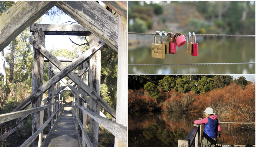
Now, heading out clockwise around Lake Daylesford, from the main car park off Bleakley Street, we reach the spillway, its guidewires festooned with lovelocks, poignant little emblems of personal commitment.
The words “40 years married,” are etched onto the nearest lock on which my camera lens lands.
Sauntering along, discussing diverse things and feeling fairly glad we’ve worn serious coats, we complete the Lake Daylesford circuit and cross Bleakley Street, heading left along the path that takes us past the rear of the Lake House to Wombat Flat Springs.
We then follow the lake edge to reach the boardwalk and continue on to the end of the boardwalk. Here we need to wake up and pay attention as about 30 metres or so past the boardwalk we must take a grassy and indistinctly marked uphill track to our left, and follow it until we reach bitumen Burrall Street.
There we turn left and continue on, the caravan and cabin park on our right, to the intersection with Ballan Road near the entrance to Victoria Park. From here we cross the Ballan Road and walk just a short way to our right to pick up the Jubilee Lake walking track that’s marked with a weather-faded sign.
The walkers who were braving the elements at Lake Daylesford are now nowhere to be seen. It’s instantly just us and the kookaburras.
The track meanders along, continuing straight ahead, through the bush and past private properties until it reaches the bitumen Lake Road.
Here we turn left and walk about 30 metres to spot an ever-useful Great Dividing Track/Goldfields Track sign marking the way ahead, on the other side of the road.
From here the beautifully tree-lined track leads gently uphill until we reach the old railway footbridge at the far northern end of Jubilee Lake.
We cross the old bridge beneath which water rushes after a little recent rain, and we keep walking in an anti-clockwise direction around the glittering lake edge toward the kiosk with its damply upturned colourful canoes dreaming of summer.
Suddenly a brilliant, sparkling burst of gorgeous winter sunlight turns the lake surface to a sheen of dancing diamonds.
Paddy H and I choose a sun-splashed park seat alongside the silvery spectacle on which to have a late lunch and coffee. But no sooner have we unravelled the first sandwich than the delicious sunlight vanishes, to be swiftly replaced by a scud of dark cloud that dispenses first drizzle then decisive showers.
We grab up our camera gear, backpacks and lunches and go helter-skelter for the nearest shelter, counting our lucky stars there’s one to be had.
And here we sit for a good half hour, lunching, reading the walk notes for the section ahead and waiting for the cloudburst to end.
After a while it does and we resume, following the lake’s edge, keeping it to our left for a kilometre or so until we reach the mossy wooden footbridge at the lake’s southern end.
We cross and continue on, anti-clockwise, headed back around the lake toward the old railway bridge. At the entrance to the old bridge we now turn sharp right and climb up a steep short flight of steps to enter the old railway line.
Later, a spot of research enlightens us that: “opening in 1887 and closing in 1953, the Ballarat to Daylesford railway line ran from the North Creswick railway station northeast across Jubilee Lake to connect with the existing Daylesford- Carlsruhe (Bendigo) railway line, launched in 1880.
“The construction of these two railway lines was part of the railway-mania that accompanied and fed the property speculation boom of the 1880s. Every town and hamlet agitated for a railway line. They were regarded as both a symbol of progress and a passport to prosperity”.
Admiring the tall eucalypts, noting evidence of wombat habitation, we walk on until we reach the intersection with a gravel road where an Italian Hill sign is visible.
We turn left and walk downhill for about 50 metres to find a Great Dividing Trail sign. We turn right here and follow the track downhill and across a little gully, following GDT signs and then climbing fairly steeply up to Cornish Hill and its pine tree forest ambience.
From here we basically just follow the path past the old Cornish Hill gold mining relics down and back into town, emerging at the skate park and walking down to Ruthven Street.
We turn right and pick up the well-made path leading back to the lake edge to complete the last scenic little stretch of Lake Daylesford in a clockwise direction, reaching the car park just as the drizzle sets in again on dusk.