November 9th, 2024Walks of the Central Highlands
with Eve Lamb

Mount Greenock Geological Reserve summit and return
We’re “guinea pigs” today, joining the Great Dividing Trail Association on a walk led by Professor Barry Golding. It’s a kind of test run for a walk forming part of a fairly spesh little public tour series that Prof Golding will lead in early December. More on that later.
The walk we’re tackling this fine Sunday is described on the GDTA website as focusing on a number of lesser known legacies associated with Mount Greenock volcanic crater in southern Dja Dja Wurrung Country.
These include a Deep Time perspective, Major Mitchell’s visit, deep lead mining and a history of licenced and unlicensed grazing on the present-day Mount Greenock Geological Reserve.
After we climb Mount Greenock we’ll also visit the public Scenic Reserve across on neighbouring Mount Glasgow before we head on to nearby Merin Merin wetlands reserve, steeped in Aboriginal heritage going back thousands of years, for a lunch stop.
It’ll be 5km walking and 20km car travel between sites all up but for the purposes of this article, I’ll focus on Mount Greenock.
The Mount Greenock Geological Reserve is located between Talbot and Clunes, accessible off the Marybrough Road, on the right just past McCallum Creek as you head toward Maryborugh.
Paddy H and I roll through the gate of the public car park, entry to the 120 hectare Mount Greenock Geological Reserve, fairly early for a Sunday, to rendezvous with members of the GDTA including Prof Golding.
Prof Golding is soon to launch a book featuring six of the notable peaks of this wider region, Mount Greenock included, and the notable legacies that surround them.
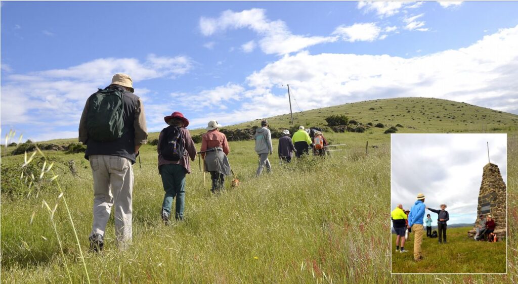
There’s 15 of us walking today and after a bit of obligatory chit-chat we set off. It’s only about one km up to the top. Not far, but a really punchy little walk to the summit that stands 385 metres above sea level.
“There is no track. There is no right way up. Choose your path,” says Prof Golding, a tad Buddhist- koan-like, as we move off as a group.
As we slowly gain elevation, Prof Golding stops to tell our walking party about the volcanic rock we’re now seeing strewn about, while also keeping a careful weather eye out for snakes at this time of year.
“Once you get up here you get basalt,” he says.
“And this is ropey lava with a flow structure,” he says, picking up a largish chunk. The basalt to be found here is so light it can just about float in your bath.
There’s scoria and “tear shaped volcanic bombs” some containing the semi-precious gemstone olivine, ancient and dating back to the time of the volcanic activity that formed this landmark local peak “an estimated half a million years ago”.
“It’s quite young in geological terms,” Prof Golding says.
As we climb, the vista above is profoundly photographic, the sky huge.
Prof Golding talks about the importance of this place to the Indigenous people over many thousands of years, as all around us the view expands.
Below and beyond the grasslands stretch and sing.
“What you see now is what was here on contact,” Prof Golding says of the extinct volcanic cone that is Mount Greenock itself. “Major Mitchell who climbed up here in 1836 described a bald green hill…”
“The rich grasslands were like a highway for the Aboriginal people. There were emus, kangaroos, wallabies, lots of small mammals.. There were silver banksia, bulloak, sheoak.
The grassland “highway” could be followed all the way to the coast at Portland, something f which Major Thomas Mitchell also made good use, we learn.
About half way up, Mount Kooroocheang appears on the horizon and with each step we take toward the summit of Mount Greenock more volcanic hills and peaks can been seen all round.
“We’re high enough here at 385 metres to see back over the Divide to the south,” our guide says.
Here, at the top there’s a stone monument to Major Mitchell’s trek in 1836. We stop and Prof Golding talks about the impacts on the Aboriginal Traditional Owners that followed the arrival of the Europeans with their grazing ambitions in this area.
It’s not a happy history and is something that Professor Golding does not shy away from in his soon-to-be-launched new book, Six Peaks Speak: Unsettling legacies in southern Dja Dja Wurrung Country. He is also keen to highlight the rich Aboriginal legacies that remain in the landscape today.
In the days leading up to the book launch on December 11, Prof Golding will lead a series of walks associated with the six peaks that act as focalisers in the book.
Mount Greenock is one of the six, and the walk we’re on today will be repeated for anyone keen to sample it at first hand. You can find out more and register to participate in the upcoming led walks through the Great Dividing Trail Association website. Just go to ‘ Events’.
But now, we “guinea pigs” are finally standing atop Mount Greenock. And the view is amazing – 360 degree of shimmering panorama. Peaks, volcanic grasslands and hills.
“I suggest you download the PeakFinder app,” Prof Golding says. One of our party, a local teacher keen to know more so as to share that knowledge with his students, immediately does so – for a cost of $8 apparently.
From where we now stand, we learn, there are 180 “visible” peaks – weather and treeline dependent – including Mount Buninyong and Mount Warrenheip way off near Ballarat, and even Mount Cole and Mount Warrenmang roughly to the west.
It’s a view more than worth walking for. Be sure and pack a picnic.
Words & Images: Eve Lamb


