
April 27th, 2024Walks of the Central Highlands

with Eve Lamb
Andersons Tramway Walk … plus. Mollongghip
Today we’re tackling the Andersons Tramway Walk at Mollongghip just east of Newlyn. This 8km (16km return) bushwalk is a bit of a surprise packet. Who could have guessed there would be a “tramway” running through the bush here?
When I say “tramway” what we’re talking about is the remnants of a cleared pathway through the bush where work horses, and later steam engines, once used to cart out heavy felled timber that was destined for the crazy ol’ gold fields of the day.
This walk basically follows that cleared haulage route that remains, over-grown yes, but still clearly visible as it makes its way to where the township of Wombat once existed back in those roaring days.
Now there’s nothing left to indicate the fact that a township ever existed here other than a cleared flat section that used to be the town’s railway siding. Adjoining this is the clear remains of where the old Ballarat to Daylesford railway line once ran.
The railway tracks have long since been taken up but the rail-line today forms part of what, for bushwalkers, has become the Wombat Station Walk – a 19km long hike from the old Wombat town site to Daylesford via Sailors Falls.
My walking accomplice Paddy H and I decide we will also do just a little bit of this walk as well as our main focus, the Andersons Tramline Walk, so as to check out the significant rail cutting that remains with walls that reach up to 20 metres high according to the literature.
This section, with the impressively high walls, immediately joins the end of our Andersons Tramway walk. It will add about two kilometres (four km the round trip) but is well worth it. Fortunately, when we set out we are fueled with the recent spoils of Easter and could use a good trek.
So to the start : The eight km Andersons Tramway Walk starts off from the Slater Road, Mollongghip, and follows the route of the old tramway through the Wombat State Forest along the top of the divide at 700metres.
According to my pre-walk research*, the Anderson brothers arrived from Scotland to try their luck on the goldfields in 1851. Instead of digging they cut and supplied timber to the ever-hungry mining industry.
Having cut their way through most of the timber at Dean they then built a horse-drawn (and later steam) tramway into the Wombat Forest. This tramway was no temporary construction as cuttings were dug, bridges and embankments built and iron rails laid for over 23 km of track. However, before long they cut themselves out of a job.
Starting again in another venture the unstoppable Andersons concentrated their attention on flour milling by constructing the massive bluestone mill in Smeaton in 1862. The imposing multi-story mill at Smeaton remains today as a monument to Victoria’s pioneers.
Reflecting on the spirit of those driven yesteryear sorts, Paddy H and I navigate our way successfully to the start of the tramway walk, parking near the intersection of McPhans, Gleesons and Slaters roads. We set out carrying maps and lunch. And it quickly turns out to be a beautiful bushland walk, the remnants of the old tramway, readily identifiable along the way.
About three kilometres in we meet a small walking party of three women, heading in the opposite direction to us, and all equipped with walking poles and determined expressions. We stop for a track-
side chat and they tell us they are Melbournians and are on a bigger, ongoing mission to complete the entire Goldfields Track, of which this walk is but a section.
“We’re doing it over multiple visits, one section at a time, all the way through from Bendigo to Mount Buninyong,” one of them tells us.
“And we always make sure that when we come back to do a new section we park the car at the exact spot where we ended the previous section so we don’t cheat,” another adds.
They obviously got started a fair bit earlier than we did today as they also tell us that they set out from Sailors Falls near Daylesford today.
“Did you see any other points of interest along the way?” I ask them.
“There’s the dam,” enthuses one of the three trekkers.
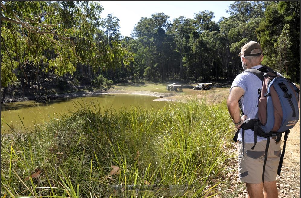
We bid them farewell and a bit further on stop track-side for lunch, accompanied by the mysterious musical calls of choughs, before making our way on to the dam. Mullens Dam which, my research informs, was built to supply water for the old gold sluicing works.
Today the Easter holiday break is still in full swing and Mullens Dam turns out to be hosting a couple of campers, very snugly set up with all the comforts. One man dozes in the afternoon sunshine. Anther looks very like he’s about to do the same. A wine glass rests languidly on the arm of a comfortable camp chair.
“Happy Easter,” says Paddy H who appears slightly affected by the season.
“Thanks,” says the man with one of the elaborate camp setups.
The late flush of Indian summer sun beats down. The bush-land all around hums with unseen life. The dam water is still and green, framed by eucalyptus leaves.
“Your Easter eggs might melt,” Paddy H helpfully advises the man.
“Nah Mate. They’ll be right. I’ve got a fridge,” he says.
“Camping aint what it used to be,” observes my walking accomplice as we move out of earshot.
From here we gain a little more elevation as we head on toward where the township of Wombat apparently once existed. Today there’s no trace, but the spot where this little gold town once stood may still be identified by a picnic rotunda that’s also accessible by vehicle off the Rocklyn Road at this point.
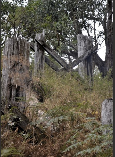
Reaching it now means we have now covered eight kilometres and completed the Andersons Tramway Walk. We stop for a coffee refuel, and then take a short 2.5km ramble along the Rocklyn Roadway toward where a yoga ashram now operates. We do this in order to photograph the skeletal remains of a timber railway bridge that formed part of the old Ballarat to Daylesford railway line which, the literature informs, opened in 1887 and closed in 1953.
Achieving this goal successfully we then return to the Wombat station site again and rally our energies to tackle a further couple of ks on the adjoining Wombat-Daylesford walk section, just so as to check out the railway cutting section with the high walls.
Almost immediately after embarking on this section of track, headed toward Daylesford, the anticipated cutting walls appear, rising up on either side of the trail, creating a small microclimate in which Paddy H and I notice three different types of thriving ferns including tree ferns.
The walls, are cut through clays and bedrock, and peering up at them we reckon the literature is not exaggerating when it says they reach up to 20 metres. We briefly wonder at what it is that motivates humanity through times past and present to tackle such undertakings.
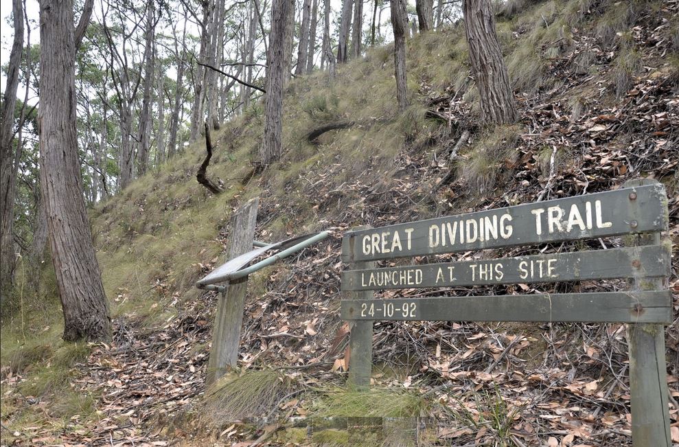
After about two kilometres we reach the point where the Great Dividing Trail (GDT) was officially launched in October 1992. Signage marks the spot.
The GDT here also follows the remnants of the dismantled Ballarat-Daylesford Railway. At this point Paddy H and I have now covered a bit over 12 kms all up when you count our small addendum ramblings, and it’s well time to head on back.
Promises of a hearty dinner and a glass of wine provide useful motivation to help combat our increasing bone weariness as we retrace our steps through the bushland’s lengthening shadows.
As we once again pass Mullens Dam, headed back, the man with the fridge is flat out, blissfully asleep in his commodious camp chair.#
Words and Images: Eve Lamb
*Walks, Tracks & Trails of Victoria. Derrick Stone. CSIRO Publishing 2009