May 27th, 2024Walks of the Central Highlands

with Eve Lamb
Tipperary Track, Daylesford – Tipperary Springs to the Blowhole via Bryces Flat and return (8.6km)
‘One day,’ I’d always thought, while driving past the Twin Bridges picnic area on the Midland Highway just out of Daylesford.
Well today was the day. Sort of…
A preliminary reconnoitre visit revealed an officious little sign, instructing that The Tipperary Track between Twin Bridges and Tipperary Springs was currently closed. Although I could see folk – and their dogs – enjoying this “closed” section of the track that I had in mind to explore, I decided discretion was needed.
Afterall, the beauty of Daylesford’s Tipperary Track (total distance 16km from Lake Daylesford to Hepburn Springs) is that you can divide it neatly into sections.
So, with Paddy H along for company on a recent sunny Sunday, we set out to sample the section of the Tipperary that follows Sailors Creek, starting at Tipperary Springs and continuing on to Bryces Flat (3.3km) … then a further 1km to The Blowhole, making a leisurely 8.6km the round trip.
Driving first to the Tipperary Springs picnic ground, (via the Midland Highway and then Tipperary Road) we first spent some time appreciating this beautiful little spot and Paddy H struck up a conversation with a man filling multiple bottles at the spring.
“Been drinking it all my life,” the man said, exuding good health.
Paddy H sampled some of the water. “Try it,” he suggested. “This one tastes good.”
Promising I would, later, we set off following the footpad that runs along the western side of Sailors Creek, and quickly affords very pretty views, from surprising elevation, down over the creek.
Stone relics from the 1800s mining days are visible along the way, and after 3.3 km Bryces Flat made a great stop for a creek-side lunch.
Paddy H struck up a conversation with a young man who was busy fossicking for gold in the creek.
“Found anything mate? Paddy H enquired.
The dude had. Some tiny, weenie little flecks of gold and also some garnets which he said he planned to “facet”.
Later, following this exchange, I thought it prudent to do a bit of research to determine the legalities around fossicking for gold in the Sailors Creek, and was relieved to find that: “Fossicking for gold is permitted along Sailors Creek – all adults must hold a current Miners Right to engage in fossicking”.
Fully caffeinated after our lunch stop, we continued on, crossing over the Bald Hill Road creek ford and resuming the walking track on the eastern side of the creek, after following the road uphill, and to the left, for a very short way, passing a house in the process.
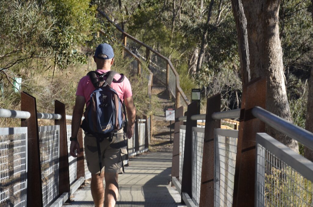
A really lovely bushland kilometre further on we arrived at the Blowhole which features a newish boardwalk and lookout from which a beautiful view down over a tranquil pool below well rewarded the effort made to get here.
But to appreciate said Blowhole it was necessary to walk down to the bottom of the steps here, and then look up from which point this man-made diversion tunnel was suddenly evident.
At the top of the boardwalk section signage had offered a potted history of The Blowhole Gold Diversion Tunnel which is listed on the Victorian Heritage register for being both historically and scientifically important.
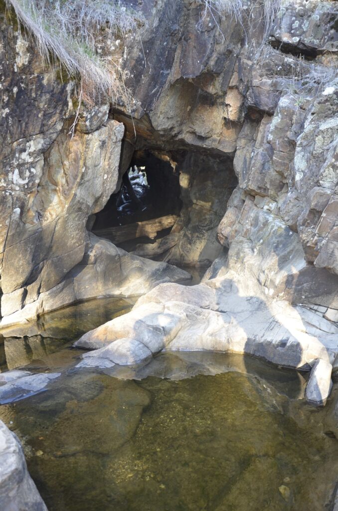
The tunnel was created by the diversion of the creek and estimated to have been built in the early 1860s when the area was being extensively worked by European and Chinese miners.
It was used to divert the creek waters, cutting off a section of the original creek alignment and enabling the resultant dry creek bed to be extensively worked by the gold-smitten.
A 2005 photo included as part of the signage shows the tunnel after heavy rain, and it is an impressive sight.
After lingering at this beautiful and history-rich landmark for about half an hour, we then retraced our steps, well pleased to have finally explored some of this great local walk and already looking forward to sampling some more of it into the future.
One word of warning, though: take care to watch your step on the Bryces Flat-Tipperary Springs path as the drop-off is both steep and very close to the edge in places.
Words: Eve Lamb